
THE PROJECT
SUBGEO aims to fully develop an integrated multiscale and multiresolution geophysical investigation approach for the coastal underground freshwater reservoir non-invasive characterization and to gain useful tools for the optimal and sustainable management of the coastal areas and resources.
In the present and future times, the climate changes may impose drastic modifications in water resources management strategies.
The continuously increasing exploitation of surface water and groundwater resources coupled with reduction trends of actual rainfall and recharge, are constantly leading to a depletion of the total available resources of high quality. It is hence strongly necessary to protect used water resources and to find alternative or further fresh water sources . In this context, coastal areas, intended as the transition zones between land and marine environments, deserve special attention. Here it takes place the inward flux (from sea to
land) of saline water but also the outward groundwater flux into the sea. The inward flux, also known as saline intrusion, is relevant due to its influence on land usability, depletion of the total available freshwater resource and or to a lowering of its usability in the coastal areas. The outward flux, less known that the former one, occurs only in particular hydrogeological conditions and is seldom indicated as submarine groundwater discharge (SGD). The presence of these two fluxes causes coastal areas to play a double role: as site of the inward fluxes, the role fragile zones to be protected; as site of outward fluxes, the role of not negligible resource for water supply. Nowadays, the outward fluxes are generally considered lost or not exploitable resources because of their difficult
characterizations.
SUBGEO aims to fill this informational gap, operating on the largest Italian coastal aquifer, the Apulia region where the coastal aquifers fed the highest concentration of submarine springs and SGD. The project will develop an innovative geophysical approach based on the integrated use of aerial, land, land-marine and marine geophysical electric and electromagnetic techniques in order to provide spatially continuous and high-resolution information on the subsoil structure from the offshore areas, where the outward fluxes mix with the sea water, to the onshore ones. SUBGEO will be tuned by small scale laboratory experiments and by numerical simulations to define the best acquisition procedures and check the sensitivity of the strategy for different subsurface conditions. Finally, the proposed approach will be tested in two significant areas to create refined hydro-geophysical models useful for an aware use of the inland subterranean water resources (hence limiting the development of the inward fluxes) and for the
possible exploitation of the outward fluxes.
State of the art
Coastal groundwater systems represent a not negligible resource for water supply. Thus, delineating coastal hydrogeologic structures, or hydrostratigraphy, is a crucial step for the characterization of groundwater flow and management of groundwater resources. Furthermore, hydrostratigraphic complexities play a fundamental role for the interactions occurring between the coastal aquifers and marine ecosystems and influence the transport solutes to coastal waters, and the response to the climate change.
However, as coastal groundwater investigations are addressed to characterize and monitoring on the onshore resources and coastal fringe processes, the interactions between fresh groundwater within submarine aquifers remains poorly explored.
Worldwide, coastal areas are attracting growing numbers of people. The increasing water demand on the global scale because of per capita demand and population increases causes a strongly increasing exploitation of the available high-quality water resources, increasing the risk of salinization via mixing for seawater intrusion. These trends can be further worsened in large areas by the enduring effects of climate change. All these conditions are causing stress on water resources of coastal aquifers. The management efforts require more knowledge on coastal springs and SGD, to preserve residual fresh resources and to find the freshest possible groundwater for desalination .
Nowadays geophysical methods are widely applied for subsoil multiscale and multipurpose characterization as they can represent with high resolution the coastal groundwater potential assessments. Their sensitivity to the variations of physical properties and their impact from low to null on the places where they are applied allow their extensive use also in fragile environments such as the coastal areas. In this framework, electric and electromagnetic geophysical methods are among the most commonly used due to the fact that water and salty water have a relevant influence on the electric and electromagnetic signal propagation within the subsoil. Geoelectric method is the most applied geophysical methodology in coastal areas for identification of seawater intrusion effects for monitoring the seawater interface , for retrieving the structure and geometry of coastal aquifer systems and characterizing coastal alluvial aquifers.
Ground penetrating radar is less effective in saline scenarios for well-known radar attenuation phenomena, but it can provide the most high-resolution information for the characterization of the shallower areas close to the sea. Its usefulness is proven for the characterization of coastal dunes, for identifying the sea water-ground water interface, to image ground water surfaces of shallow aquifers in coastal area and for identifying overwash deposits due to marine inundation or washover events impacting a coastline. The use of aerial systems for data acquisition coupled to advanced techniques of data processing represents a challenging topic with interesting implications for the monitoring of large areas as in the case of coastal areas. Although nowadays frequency ElectroMagnetic Induction (FDEM or EMI) methodology is little used, thanks to its non-invasivity and capability to cover large areas over a short period of time it can be an optimal tool for hydrogeological reconstruction also in coastal areas. EMI is used for mapping saltwater intrusion with airborne and terrestrial methods; for mapping barrier island framework geology to investigate submarine groundwater discharge in the littoral zone. Drone-based EM surveys represent a new frontier for the accurate understanding of the fresh–saline groundwater distribution as they allow to reduce the costs associated to the classical airborne surveys.
Multidisciplinary approaches based on the integration of hydrogeological and geophysical investigations are successfully applied for analyses of coastal aquifers as they provide useful information for detecting the potential zones of groundwater recharge in the arid coastal regions and characterizing submarine groundwater discharge.
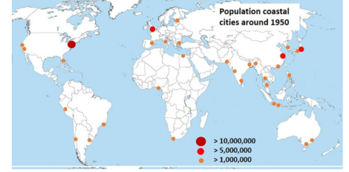
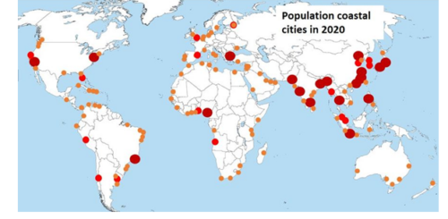
Coastal cities have experienced tremendous growth in recent decades
- Low-lying coastal city population increased from about 360 million in 1990 to about 500 million in 2015
- in 2020, 197–347 million people lived in coastal areas less than 2 m above sea level, of which 59% in tropical Asia and 10% in tropical Africa (Hooijer and Vernimmen, 2021).
- An important part of the economy of coastal states is concentrated in these centers.
- By 2050, two-thirds of the world’s population is expected to live in cities and by then an estimated 800 million people will live in more than 570 coastal cities that are vulnerable to a 0.5 meter rise in sea level (WEF, 2019)
Global urban population facing water scarcity was projected to double from 933 million (33%) in 2016 to 1.693–2.373 billion (35–51%) in 2050, and the number of large cities facing water scarcity under at least one scenario was projected to increase from 193 (37%) to 292 (56%).
The problem of water supply represents a priority for not only the Mediterranean Area but for the World if we consider the age-old problem of the drought exacerbated by the climate change events that are constantly seen.
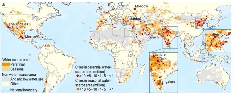
THE URBAN PROBLEM
Urbanization and climate change are together exacerbating water scarcity—where water demand exceeds availability—for the world’s cities. (He et al. 2021)
- Growth in urban population
- Water demand
- Climate change
increase in urban water scarcity
Potential solutions to urban water scarcity
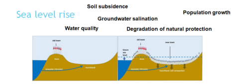
Coastal aquifers are fundamental for water supply as they represent the transition zone where inland freshwater fluxes interact with saline seawaters.
Here the inward flux of saline water takes place but also less known outward groundwater flux into the sea can be observed. The inward flux, also known as saline intrusion, is relevant due to its influence on land usability, depletion of the total available freshwater resource and or to a lowering of its usability in the coastal areas. The outward flux, less known that the former one, occurs only in particular hydrogeological conditions; it is known as submarine groundwater discharge (SGD).
Coastal areas are challenging places for the application of geophysical methodologies.
At present time, the relatively few surveys aimed to characterize the coastal areas are usually performed by joint together land and marine surveys. This practice, whereas of simple applications, has a relevant limit.
The boundary area between the sea and the land, the area close to the shore, remains poorly or not investigated neither by the land survey nor by the marine one.
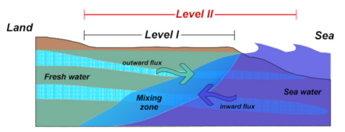
The continuous exploitation of surficial and underground waters coupled with a possible reduction in the rain events due to the global warming will probably enhance the inward fluxes exasperating their effects of the human living conditions. It is hence strongly necessary not only to improve the subsoil knowledge for a better water resource management and preservation but also to find an alternative source of fresh water. To this aim, it is fundamental to intercept the outward fluxes and to use them for processes which
do not necessary requires fresh waters .
Seawater intrusion in Italy exists along large portions of the coast from Friuli Venezia Giulia to Marche and from Liguria to the central Latium, eastern and western Sicily, southern Calabria and the Sardinian coastal plains. Significant sea flows are documented along the coast between Monfalcone and Trieste, in front of Ventimiglia and along the carbonate coasts of Latium, Campania and Apulia.
The SGDs with the highest total yield and most continuous flow are concentrated in Apulia, involving almost all the coastline, 900 km
in length.
In most of these Italian coastal portions the risks of groundwater salinization are growing due to increasing withdrawals and the effects of climate change. The most emblematic case is again that of Apulia which is largely devoid of surface water resources due to the karstic nature of the territory. Apulia also lends itself to a favorable schematization useful for achieving results of global
significance. In fact, it allows two types of SGD-rich test areas to be selected. The first considers the portion of the aquifer straddling the coastline to be porous in nature, the second to be karst, permeable due to fracturing and karstification. The former type, referable to soils consisting of sands, gravels and calcarenites of terraced marine deposits; the latter to very wide outcrops of Mesozoic carbonate rock (Altamura Limestone).
Coastal areas, intended as the onshore and offshore areas close to the coast lines, are challenging places for the application of geophysical methods due to their being highly dynamical and fragile systems and also because they are constituted by two totally different operational conditions: land onshore and sea offshore. At present time, the relatively few surveys aimed to characterize the coastal areas are usually performed by joint together land and marine surveys. This practice, whereas of simple applications, has a relevant limit. The boundary area between the sea and the land, the area close to the shore, remains poorly or not investigated neither by the land survey nor by the marine one. Consequently, missing information on the area where sea water and ground water start to interact, the reconstruction of the hydrogeological processes in the coastal area may be inaccurate or not complete.
To overcome this limit, SUBGEO aims to setup an innovative investigation strategy able to furnish continuous information from the land to the sea useful to define the water fluxes dynamics. It will be a two-levels based strategy in which the levels will be not necessarily consecutive and interdependent. Through the use of electromagnetic aerial and terrestrial methods, the first
investigation level will provide an expeditious and not expensive overall characterization of the geophysical framework of the investigated area. The outcomes are not intended to be detailed product to be integrated in any hydrogeological or geological study but will furnish basic elements useful for the design of detailed surveys or in the first phase of selecting areas to be used for potential specific objectives (e.g., the installation of a desalination plant). The second investigation level will include a more complex integration of electrical and electromagnetic geophysical methodologies and will be the more informative. The expected results will consist in a multiscale and multiresolution subsoil characterization from land to sea, that crossing the shoreline, will not have any spatial informational gap. The outcome of the second investigation level will support the creation of optimized hydrogeological models of the investigated area and can also be directly used by the decision maker to implement sustainable water resources
management strategies.